

TPA will remain operational through the Wednesday flight schedule and plans to resume services when it is safe to do so Friday, but passengers should check with their airlines regarding flight schedules.
Tampa International Airport will suspend all commercial and cargo operations beginning at 2 a.m. Thursday ahead of Hurricane Helene, with the Airport remaining closed to the public until it can assess any damage after the storm.
The Airport and its partners will use time ahead of the suspension to prepare the airfield and terminals, including the securing of jet bridges, ground equipment and any remaining aircraft before the storm arrives Thursday. The three other public airports managed by the Hillsborough County Aviation Authority – Peter O. Knight, Tampa Executive and Plant City Airports – will also close at 2 a.m. Thursday.
TPA, including the Main Terminal and Airsides, will not be open for public use and is not equipped to function as a shelter for people or vehicles.
The Airport anticipates reopening Friday following a damage assessment that will begin as soon as it is safe to do so. TPA will closely coordinate the reopening of the Airport with its partners, including the Transportation Security Administration and airlines, based on roadway safety, facility readiness and staffing. Any changes to the timing will be promptly communicated.
Important reminders for passengers:
- Please contact your airline for the latest flight information. TPA will announce if flight operations are affected by the storm, but airlines are responsible for their schedules.
- Monitor the weather closely. Please stay up to date on forecasts for your area and any regions to which you may be traveling to or from.
- Follow TPA social media for the latest updates. Our account on X (formerly Twitter), @FlyTPA, will be the place to find the latest updates.
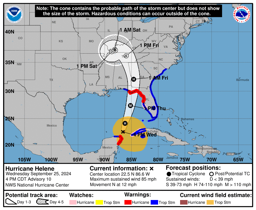
From national Hurricane Center:

- A catastrophic and deadly storm surge is likely along portions of the Florida Big Bend coast, where inundation could reach as high as 20 feet above ground evel, along with destructive waves. There is also a danger of life-threatening
storm surge along the remainder of the west coast of the Florida Peninsula. Residents in those areas should follow advice given by local officials and
evacuate if told to do so. - Potentially catastrophic hurricane-force winds are expected within the eyewall
of Helene when it makes landfall in the Florida Big Bend region late Thursday. Preparations to protect life and property should be completed by early Thursday
before tropical storm conditions arrive. Damaging and life-threatening
PurionsofnotheFiondaandsouternCeorgalateThursdayandThursday night where Hurricane Warnings are in effect. Strong wind gusts are also likely farther north across portions of northern Georgia and the Carolinas, particularly
over the higher terrain of the southern Appalachians. - Catastrophic and life-threatening flash and urban flooding, including landslides, is expected across portions of the southern Appalachians through Friday. Considerable to locally catastrophic flash and urban flooding is likely
for northwestern and northern Florida and the Southeast through Friday. Widespread minor to moderate river flooding is likely, and isolated major river
flooding is possible. - Hurricane and tropical storm conditions are expected over northeaster
portions of the Yucatan Peninsula of Mexico this evening where Tropical Storm and Hurricane Warnings are in effect. Tropical storm conditions are occurring over portions of western Cuba within the Tropical Storm Warning area, and hurricane conditions are possible this evening within the Hurricane Watch area. Helene will bring heavy rain to portions of the western Caribbean with potentially
significant flooding across western Cuba and the northeastern Yucatan Peninsula
into early Thursday.